by
By Richard Greenberg*, Gregory V. Hoppa*, B.R. Tufts*,
Paul Geissler*, Jeannemarie Riley,* and Steven Kadel**
For Submission to Icarus
November 25, 1998
*Lunar and Planetary Laboratory
University of Arizona
Tucson, Arizona 85721-0092
**Dept. of Geology
Arizona State University
Tempe, AZ 85287
Manuscript pages: 33 (including figure captions)
Figures: 19 (some with multiple parts)
Tables: None
Key words: Europa, Geological Processes, Ices, Tides,
Thermal Histories
Running head: Chaos on Europa
Address editorial correspondence to:
Richard Greenberg
Lunar and Planetary Laboratory
University of Arizona
1629 E. University Blvd.
Tucson, Arizona 85721-0092
Phone: 520-621-6940
Fax: 520-621-5133
e-mail: greenberg@lpl.arizona.edu
Chaos on Europa
Abstract
The characteristics of chaos regions on Europa suggest they may be sites of melt-through from below. They are wide-ranging in size, location and age. Most are similar to Conamara with a matrix reminiscent of frozen slush, and often rafts of pre-existing crust. Edges are of two types: ramps, perhaps the tapering of crustal thickness to zero, or cliffs where rafts appear to have broken clear from the shore. Of the lenticulae, "spots" generally appear to be small chaoses with textured matrix and occasional rafts, "pits" may represent incipient melting nearly at the surface, and many "domes" may be small chaoses raised by isostatic compensation following refreezing of the crust. The extent of chaoses often appears to be limited by ridge systems with the coastline parallel and set back by a distance comparable to the width of the ridge system. Pre-existing ridges often survive as causeways or chains of rafts. Boundaries of chaoses are apparently not controlled by pre-existing cracks, consistent with formation by a thermal, rather than mechanical process. Ridges may thicken the crust such that melt-through is more likely (but not always) between ridge systems. Subsequent cracks and ridges form across pre-existing chaoses, ranging from fresh cases with few cracks or ridges across them (with paths somewhat jagged as they meander among rafts) to heavily dissected examples. Isolated tilted raft-like blocks surrounded by densely ridged terrain may be the only remaining evidence of former chaotic terrain. Thus two fundamental resurfacing processes have alternated over Europa's geological history: melt-through (at various places and times) forming chaos terrain, and tectonic cracking and dilation building densely ridged and banded terrain. Mapping of chaos features based on morphology at 200 m shows that they correlate with dark regions in global (2 km resolution) mosaics (except dark regions due to ridge margins or craters). Considerable area has been available globally to accommodate the expansion of crust that occurs along extensional ridges and bands. Chaos ubiquity suggests Europan geology has been dominated by the effects of having liquid water under a very thin ice shell, with chaos regions being widespread indicators of occasional zero shell thickness.
I. Introduction
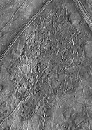
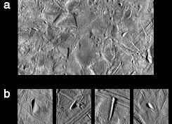
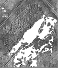
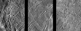
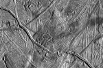
Early imaging of the surface of Europa by the Galileo orbiter included high resolution coverage of the area named Conamara Chaos, which may be the archetype for a wide-ranging class of terrain (Fig. 1). Conamara is an area where previously existing densely ridged terrain has been disrupted. It contains displaced blocks that have the appearance of rafts of previous terrain floating in a rough and jumbled matrix. Carr et al. (1998) interpreted Conamara as the surface manifestation of subsurface convection, either of liquid water or solid-state ice.
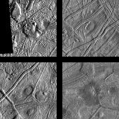
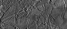
Related categories of features have been called "pits, spots, and domes" (Pappalardo et al. 1998). Many of these features are visible at low resolution (km-scale) as albedo spots, and have been dubbed "lenticulae". They are generally round and 5-15 km in diameter, and include a wide variety of features believed by Pappalardo et al. to be genetically related, although that conclusion may depend on more precise definition of what features fit into each category. The range of features that might come under these names is so diverse that care is needed in defining them in conjunction with any model of their formation. Most of the features in these categories (in fact nearly all of them in the taxonomy of "pits, spots, and domes" of Head (1998)) have considerable similarity to Conamara Chaos, with interior textures similar to Conamara's matrix, similar boundaries, and occasional blocks similar to Conamara's "rafts" (Fig. 2).
A model for the formation of pits, spots, and domes as the tops of upwelling convective cells has been proposed by Pappalardo et al. (1998). Based on an argument for the plausibility of convection in an ice crust ~10-15 km thick, they explained the putative common size scale and spacing of all these features as reflecting the expected scale of the convection cells. While that model is appealing, there remain a number of issues to be resolved. For example, McKinnon (1998) found that convection is uncertain in a crust of that thickness given the range of plausible values of the viscosity of ice. Also, whether the morphologies of pits, spots, and domes are what would be produced if there were solid-state convection or other diapiric upwelling remains a matter of speculation. Another concern is whether the 5-15 km scale of pits, spots and domes is an artifact of the definition of such features by size (Head 1998).
To address the size and spatial distribution of chaos terrain, as described in Sec. IIA we have mapped and catalogued all areas with fundamental similarities to Conamara Chaos over as much of the surface of Europa as has been imaged at appropriate resolution by Galileo through orbit E15, which includes far more data than had been available to Pappalardo et al. (1998). We find a continuum in size of chaos-type areas, from the scale of the "pits, spots, and domes" up through the size of Conamara Chaos and even larger examples, hundreds of km across. Moreover, the small size cut off, below about 5 km, may have been an observational selection effect, rather than a representation of any meaningful physical limit: There are numerous examples smaller than 5 km, though often not recognizable except at higher resolution. Thus the identification of the scale of any of these areas as an indicator of typical convection cell size was premature.
Another interpretation of many of the areas that we identify as chaos-type terrain, including many of the domes identified by Pappalardo et al., has been as viscous volcanic flows (Greeley et al. 1998, Schwarz et al. 1998). (The term "cryovolcanic" is often used to clarify that the material involved is cold water and ice, rather than molten lava and rock.) This interpretation is based on the similar appearance to volcanic analogs on Earth and elsewhere in the solar system, especially the slightly domed appearance, the lobate character of the edges suggestive of viscous flow, and cracks in the adjacent crust suggesting loading by flow over the surface.
Buoyancy presents a challenge for models of cryovolcanism on Europa because liquid water must rise through, and then over, less dense solid ice (as discussed further in Sec. IIIA). In contrast, on terrestrial planets volcanism can be conceptualized in global terms as part of the differentiation process, with the least dense materials rising to the surface, albeit with important local variations. On Europa, volcanic flow requires pressure chambers to force the liquid water upward (Wilson et al. 1997) or ad hoc additives to lower the density of the water (Greeley et al. 1998). In either case, the watery "magma" cannot be part of any large-scale under-ice ocean, because such an ocean could not be pressurized and, if the density reducing additives were widespread, the crust would sink. Moreover liquid water on Europa is probably a global ocean or none at all according to the classical tidal heating models (Cassen et al. 1982).
In this paper we develop an alternative model in which all chaos-type areas, from the smallest "lenticulae" up through the largest regional ones, represent the results of exposure of liquid water at the surface, due to melt-through from below. In this model, local or regional heating melts through the icy crust, starting at the bottom at its interface with a global ocean, and continuing until the crustal thickness is reduced to essentially zero over some portion of the surface. We will show how this process provides a natural explanation of the characteristics of the observed chaos-type areas.
This model is motivated chiefly by interest in pursuing an explanation of the nature of chaos areas in terms of what they simply appear to be: pools which disrupted older terrain and allowed mobility of rafts of older terrain for some time before refreezing occurred, leaving a matrix of frozen slush. The similarity of texture and morphology from regional scale chaos down to the size of lenticulae requires that a model based on this interpretation of appearance be equally able to explain characteristics of the entire class.
We have also been driven to consider a model based on the premise of thin ice over liquid water by the plausibility of our earlier model for the formation of ridges on Europa (Greenberg et al. 1998), which is also dependent on that premise. In our models, linear ridges and chaos areas both result from liquid ocean water being exposed to the surface. In another search for a mechanism common to both ridge and chaos formation, advocates of solid-state convection or diapirism as an explanation of chaos terrain (Pappalardo et al. 1998) have also proposed that ridges are built via solid-state diapirism (Head et al. 1997). That model may prove to be viable once it is fully developed, but it has yet to explain the uniformity along great lengths of ridges, the lack of pre-existing terrain on ridge flanks, or the paucity of possible central ridges of upwelled material. For these reasons we are pursuing the hypothesis that liquid water, distributed globally under the surface, has been key in producing chaos, as well as ridges.
In fact, our examination and mapping of large tracts over the surface of Europa in the context of this study suggests that ridges (including bands, which may be genetically related tectonic features according to Tufts et al. 1998) and chaos respectively define the two classes of terrain that dominate the surface. Where chaos-type terrain has not disrupted it, the surface consists of densely ridged terrain, such as that which surrounds and apparently predates Conamara Chaos. While it is evident that formation of chaos terrain can destroy earlier densely ridged terrain, it also appears that cracking and subsequent ridge formation can in turn destroy chaos terrain, restoring the ground to a densely ridged appearance (Sec. II.B.5). Thus, chaos areas are not necessarily the most recent, and chaos and ridge formation may both have been diachronous over the geological age of Europa. The two fundamental resurfacing processes may have alternated over Europa's geological history, with melt-through (at various places and times) forming chaos terrain, and criss-crossing by tectonic features (cracks, ridges, and bands) forming densely ridged (and related tectonic) terrain.
In this paper we explore several lines of evidence to evaluate the plausibility and viability of this broad vision of the geology of Europa, as well as to document the characteristics of the widespread chaos areas and to consider the possibility that they are in fact sites of melt-through from below.
II. Characterizing Chaos Regions
A. Mapping
In this paper, we introduce a definition of chaos as any area on the surface of Europa that is similar to Conamara Chaos when viewed at low illumination angles (typically ~10o from horizontal) at resolution (pixel size) ~200m. This definition is therefore based on texture and morphology, not albedo. The appearance of surface features is very different at high sun angles, where albedo dominates or confounds it. In fact we will show that the correlation between albedo and chaos character is unreliable, although under certain circumstances albedo can with care be used to infer the extent of chaos areas beyond where the appropriate low sun, high resolution imaging is available.
As defined here, chaos areas are recognized by abrupt transitions from background terrain, and a matrix texture similar to Conamara's. Generally the surface includes raft-like features ranging (as do those in Conamara) from ones large enough to show recognizable old terrain, down to small ones that merge with the general matrix texture.
The process of identifying and cataloging chaos areas was carried out over all regions on Europa where appropriate 200 m, low-sun data were available in the form of mosaics of images. These regions (all shown in Fig. 3) are: the 300 km square area around Conamara; a 300 km wide area around impact feature Mannan'an that extends about 500 km south into the west edge of the "Wedges" region; a single frame taken southwest of the crater Pwyll during Galileo's orbit E12 (the Europa-targeted 12th orbit around Jupiter); a 300km x 400km region near longitude 180o in the southern Wedges region; a 500km x 500km mosaic around Tyre; and two regional mosaics acquired during orbit E15, called "RegMap01" and "RegMap02", which cover large 300km wide strips in the northern hemisphere. Our definition of chaos based on consistent lighting angles and resolution means that we are confined to mapping in these regions only. In fact, in the Wedges region we were only able to map the eastern one-third of the region imaged at 200m, because farther west the sun angle was too high for consistent identification of chaotic terrain. Based on what we have learned, we can make tentative albedo-based inferences about the extent of chaos areas beyond our mapping regions, but the lower resolution, and/or higher sun angles, make detailed mapping beyond the regions of 200m imaging undependable.
Galileo has obtained imagery down to a few tens of meters resolution over very limited areas, generally within the regions of 200m-resolution for context. Where available, we have used such images to provide further insight into the nature of the chaos terrain. One result has been a recognition that areas that disrupt background terrain (usually densely ridged background), but which appear too smooth to fit our definition of chaos at 200m, were revealed at higher resolution simply to be chaos with finer textured matrix (Fig. 4). Thus our mapping of chaos areas based on the 200-meter-resolution definition is conservative in the sense that there are probably many more examples than we have identified, mapped, and catalogued. In general, however, those features that we have not included, because they are too smooth to identify at 200m, are small and would probably not change the global-scale picture as it is emerging from our study.
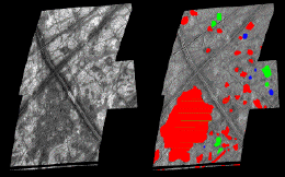
In our mapping, we have indicated most chaos areas with a red color. However, a distinct second class of chaos emerged during our study. In these regions, the surface gives an impression of having been modified in some way. Generally the matrix is relatively smooth, and the edges of the rafts are less sharp. In most examples of this class, lineaments are observed in the matrix, sometimes crossing over the rafts as well. This second class of chaos terrain is indicated in our mapping as green, although we emphasize that these are clearly, to first order, the same type of terrain as the "red class" of chaos. See Fig. 5(a) for an archetypal "green class" chaos area.
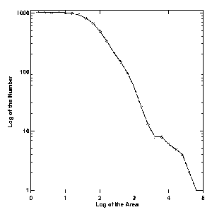
A global map of chaos terrains is shown in Fig. 3. It is overlaid on a km-scale global mosaic of combined Voyager and Galileo data. The regions of 200m-scale imaging are superimposed, with chaos regions marked by our color code. A plot of the size distribution of the chaos areas is shown in Fig.6. For chaos areas smaller than about 30 km2 (i.e. only a few km across), we find that the 200m resolution makes identification of interior features (including matrix texture) difficult, so mapping and statistics are incomplete. Current information does not indicate whether numbers of smaller chaos areas drop off, or whether the distribution of continues to increase as a power law.
In addition to the chaos areas, we identified numerous anomalous features in densely ridged terrain that have the appearance of features usually found in chaos terrain. Generally, these are topographic features with the shape and appearance of chaos rafts. Examples are shown in Fig. 5(b). Our hypothesis is that these features were created as rafts during a chaos forming event, and that subsequent cracking and ridge-building across the terrain erased most of the surrounding features of chaos regions. These features then represent the parts least susceptible to such resurfacing. Thus, isolated "fins" protruding up through ridged terrain, or polygonal plateaus underlying ridged terrain, may be artifacts of earlier chaos. In our mapping, we have identified a number of such features with blue spots. Note that we have made no attempts to identify the full extent of a chaos region that might have been associated with such features. If our interpretation is correct, these features are only "the tip of the iceberg" (often literally, as well as figuratively) representing what may have been extensive areas of chaos. Also note that we have been very conservative in marking such features. There are numerous additional features that may be candidates for the remains of chaos terrain, but we have only marked the most compelling ones. While the red and green areas unambiguously identify what are clearly chaos areas, the features marked in blue are only linked to chaos through our interpretation of their origins. Such an interpretation of the "blue" features fits the broad view of chaotic terrain developed in this paper, but it is not essential for that big picture.
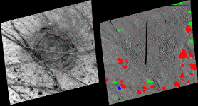
In our mapping we have defined chaos areas by their morphology, represented by their appearance at 200m resolution with low sun angles, but the same areas have been imaged with the sun overhead at a variety of scales. In the areas around Conamara and Mannan'an, there is a good correlation between lower albedo and chaos terrain (e.g. Fig. 7). The exception is where the lower albedo is clearly identified with global-scale lineaments: There, dark material borders ridge systems forming what appear as "triple bands" at low resolution. These exceptions are thus easily identified. In the RegMap01 area, where chaos areas are smaller, the correlation is also quite good, which is why many of these features were originally called spots or lenticulae. These correlations suggest that the several-hundred-kilometer-wide roundish splotches (called mottled terrain by Lucchita and Soderblom, 1982) on the trailing hemisphere of Europa may be primarily chaos regions. On the other hand, in the Tyre region on the leading hemisphere, we find that the correlation with albedo is quite poor (Fig. 8), perhaps due to brightening with age (c.f. Geissler et al. 1998). Therefore, considerable caution is required before asserting that albedo can be used to extend mapping of chaos to those extensive parts of the surface where morphology-revealing imaging is not yet available.
Our mapping based on data through orbit E15 shows that chaos areas are widely distributed on Europa. Fig. 3 shows that the amount and sizes of chaos areas vary considerably from region to region. The Conamara, Mannan'an, and RegMap02 regions have large fresh chaos areas. Chaos areas seem to get smaller and sparcer the farther north they are in the northern hemisphere in the regions where we have adequate resolution for this mapping. Generalization of such global patterns may be premature: E17 images of the south polar region show extensive chaos areas, so there may not be a preference for equatorial regions after all.
If the differences among "red", "green", and "blue" chaos areas represent chronological differences relative to ridged terrain, chaos areas may have a wide age range, as well as wide spatial distribution. In subsequent sections, we consider specific examples that show how chaos terrain may be resurfaced, yielding the kind of age sequence that we are proposing.
B. Common Characteristics
1. Matrix
Despite the wide range of global distribution and sizes
of chaos areas, there are numerous characteristics that are common to all
or most of them. By our definition, they all have matrices of similar rough
texture, with Conamara's as the archetype. The lumps that give the general
texture to the matrix appear to span a broad range of sizes, from the limit
of resolution (even where very high resolution images are available) up
to several-km rafts with recognizable old terrain on them. There appears
to be a continuum such that even the small lumps may simply be smaller
chunks of ice from the original crust, too small to have had or retained
recognizable segments of old terrain. Very high resolution images within
Conamara (such as the 40m/pixel and 9m/pixel images obtained on Galileo
orbits E6 and E12, respectively), show a range of small chunks, including
jagged lumps and what appear to be partially foundered miniature rafts.
At some very fine scale, the actual texture of the matrix medium itself
may dominate, but in Galileo images it is indistinguishable from lumps
of disrupted crust.
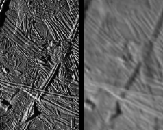
2. Littoral
The abrupt edges to chaos areas occur where the matrix material meets the surrounding terrain. This littoral is either defined by cliffs of height comparable to the height of raft surfaces above the matrix, or "beaches" where the surrounding terrain meets the level of the matrix. In most of the latter cases where the topography is discernible from the lighting, the surrounding terrain slopes down to meet the matrix (hence our term "beach"), and the matrix bulges upward away from the shore. The upward bulging of the matrix is particularly evident in many small, round chaos areas (e.g. Fig. 2). Another fine example is the coastline of the "Mitten", a Conamara-sized chaos in the RegMap02 area (Fig. 9). Often, beyond the downsloping beaches, the crust has cracks roughly paralleling the shoreline, as seen for example along the southwest coast of the Mitten. While Greeley et al. (1998) considered similar positive relief features and the cracks around their boundaries as indicative of viscous volcanic flow (see Sec. I), we interpret and map such features as examples of chaos and explain their formation (including the updomed matrix and boundary cracks) by a model of melt-through (without flow over the surface) and refreezing that also explains the other characteristics of chaotic terrain (see Sec. III).
 Figure 9
3. Rafts
Rafts large enough to retain pre-existing surface are found in many, but not all chaos areas. The largest ones cover a few percent of the chaos area in which they are located. On Conamara and elsewhere, enough rafts have sufficient old surface on them that their original locations can be reconstructed, like assembling a picture puzzle. Such a reconstruction is shown in Fig. 10, which is slightly different from the version by Spaun et al. (1998). Such exercises reveal that rafts can be highly mobile, as if they were adrift in a fluid sea. In addition, many rafts have surfaces tilted so far that they reach at least as far down as the matrix level. At their high ends, such tilted features represent some of the tallest topography on Europa (up to several hundred meters), and may be the features that remain longest (marked in blue in our mapping) as subsequent resurfacing erases chaos terrain.
Most large rafts appear to have originated at the edges of a chaos area. In many cases they have not moved far. In fact there is a continuum from rafts that have moved significantly from the edge to ones that are essentially still in place, with only cracks separating them from the edge. The Mitten has good examples of the latter, while the west side of Conamara shows modest displacement from the edge. The similarity between the heights of cliffs at the edge of a chaos area and around the edges of each raft further reinforces the impression that many rafts are shoreline features that have drifted away.
The pre-existing terrain that remains on the surfaces of rafts is generally densely covered with small, criss-crossing ridges. In some cases, the older terrain appears to have been chaos terrain itself. It appears that earlier chaos was disrupted by a later chaos forming event. Such relationships seem more common in areas that we have classified as "green" chaos, or in the enormous chaos area in the southern part (near the equator) of the RegMap02 region. In such places, distinguishing rafts from matrix is difficult, as there seem to be rafts and matrix on rafts in matrix. The stratigraphy is complex, but may be amenable to detailed analysis in future work.
4. Relation to Large, Older Ridges
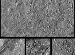
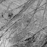
The extent and nature of chaos areas is often influenced by preexisting ridge systems. In many cases ridge systems appear to have controlled the edges of chaos areas. Generally the edge of the chaos is set back from, but parallel to, a bordering ridge. For example, Conamara is bordered in this way on two sides by Agave and Asterius Lineae (Fig. 1). Although there are a few examples of chaos areas centered on large pre-existing ridges, more generally they occur between ridges, and large chaos regions tend to have their extent limited by neighboring ridges. Several examples of ridges that form boundaries of chaos areas are shown in Fig. 11.
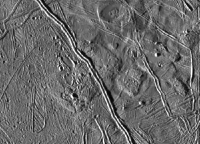
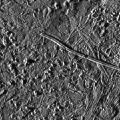
Usually where chaos areas are large and have crossed older ridges, the older ridges survive in some way. Sometimes they remain as intact causeways across the chaos (e.g. Fig. 12). Sometimes they have been disrupted in the middle of a chaos, but portions survive as peninsulas extending from the shore into the chaos (e.g. Fig. 13). Even when a ridge system is disrupted, it often survives as a chain of rafts. In fact, most rafts that are not reconstructable as portions of the coast appear to be parts of ridge systems. For example, our reconstruction of Conamara (Fig. 9) shows that the full length of the ridge pair that crossed from the east side to the southwest across this region remains on rafts, as does much of the ridge system that crossed from north to south. Other examples of chains of rafts representing earlier ridges are shown in Fig. 14.
The relationships between chaos regions and larger, pre-existing ridge systems indicate that the crust around and under the ridges is generally more able to resist the chaos-forming process, although in some cases chaos appears to have broken out squarely on the site of ridges. These observations form important constraints on any model of chaos formation, including the one that we describe in Section III.
5. Relation to later, crossing cracks and ridges
Just as regions that were already densely ridged experienced on-going cracking and ridge-building, after chaos areas form they too are subject to subsequent cracking and ridge building. Examples of chaos regions that illustrate such an erasure process are shown in Fig. 15. In all these cases, the cracks or ridges extend across the surrounding territory as well. It appears that at some point after chaos formation, the crust becomes continuous with the surrounding terrain, so that cracks and ridges can begin to modify the entire region. Some of these linear features take paths preferentially located in matrix material, picking their way around rafts. A clear example is a ridge crossing the Conamara matrix in Fig. 15a. The cracks that initiated these features probably formed at a time, shortly after refreezing, when the matrix was still significantly thinner, and thus weaker, than the rafts. Of the ridges that do cross rafts and adjacent terrain, as well as matrix, the portions across the matrix are often less developed (lower and narrower), probably reflecting a somewhat thinner crust in the matrix at the time of ridge building, according to the tidal/tectonic model of ridge formation proposed by Greenberg et al. (1998). This phenomenon is apparent in Fig. 15b for example. As the tectonic overprinting by cracks and ridges becomes dense, the underlying terrain becomes unrecognizable. Fig. 15h shows an example that may be at the limit of recognizability, possible former chaos terrain that has practically been destroyed. Implications of such destruction of chaotic terrain are discussed in Section V.
 a
a 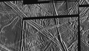 b
b 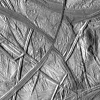 c
c
 d
d 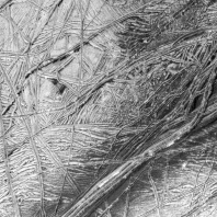 e
e 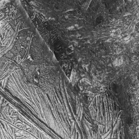 f
f
 g
g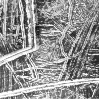 h
h
III. The Melt-Through Model
The fundamental characteristics of chaotic terrain can be explained in terms of a straightforward model in which pre-existing crust thins as it melts from below, until its thickness reaches zero for all practical purposes. Either an area of the surface is temporarily replaced by liquid exposed to space, or the ice becomes so thin that from the point of view of its mechanical effects, it might as well be liquid. Here we describe the expected nature of such a process and how it could create the observed characteristics of chaotic terrain.
A. The Basic Process
We assume that tidal heating is not perfectly uniform, but is able to heat various regions of the crust preferentially at various times. This heating might be from below, for example if the dissipation is in the solid rock beneath a liquid ocean or in the liquid itself. Regional or local concentration of heat at the bottom of the ice shell might result from convection in the liquid or from anisotropic heating in the rock. Alternatively, if the tidal heating is predominantly in the crust, unless it is perfectly uniform regional or local concentration might produce melt-through.
Consider the process of thinning a surface crust of ice over liquid water. In Fig. 16a, the ice has begun to thin from below. Because the ice is supported buoyantly, it has a float line about 10% of the way from the surface to the base of the ice, which is the level to which water would rise through a fishing hole. As the ice thins further, the buoyancy decreases, so the surface sags downward isostatically (Fig. 16b).
If melting does not continue beyond this point, the surface may be left with a depression. This isostatic sagging may provide a genetic connection between "pits" and chaos areas. Moreover, if the crust is maintained at this extreme thinness for a long enough time, surface topography may be obliterated, perhaps creating such smooth regions as the dark patch to the left in Fig. 15b, or the smooth dark margins of Thrace Macula (which has been revealed to be a chaos region by E17 images). Alternatively, it is also possible that these smooth regions are simply very smooth-textured chaos matrix.
Eventually the ice thins so that liquid is either exposed at the surface or covered by a fragile, thin skim of ice (Fig. 16c). The surface tapers to the edge of the opening where buoyancy supports it at the level of the float line. Thus the ramped beaches characteristic of the much of the shorelines of chaos terrain are formed. The liquid rises to the float line. Where liquid is exposed, its surface is agitated by boiling and freezing upon exposure to space. The active surface might spray material, including salts, organics, or whatever other impurities are contained in the liquid. The activity continues (perhaps intermittently) as long as adequate heat continues to warm the liquid. Then as the heat diminishes, the surface refreezes and a new crust forms and thickens (Fig. 16d).
The remaining surface must be rough due to the agitation undergone during exposure of liquid and during the initiation of refreezing. Lumpiness of the texture would be enhanced by any floating chunks of unmelted crust. In addition, the local surface would be darkened by the ejected impurities, analogous to the darkening agents on the margins of the large ridge systems that give the appearance of "triple bands". This process can explain the general appearance of chaos areas in terms of texture and typical darkening. Alternatively, darkening might be due to thermal annealing. In any case where floating chunks are rare, the surface may be smooth enough that it does not qualify as chaotic according to our definition (based on 200m resolution). The model explains why such areas do seem chaos-like at Galileo's highest resolution, even if they did not at 200m resolution. It also suggests that areas with the appearance of smooth, dark patches in Galileo images (e.g. Fig. 15b) are simply chaos terrain with a fine matrix texture.
As refreezing continues, the crustal thickness under the chaos area increases until similar to the surrounding crust. Isostatic compensation due to the buoyancy of the refrozen ice raises the chaos area, with the topographic discontinuity at the edge forming an encircling moat (Fig. 16e). This process explains the domed shape of many chaos areas. It offers an alternative to the viscous flow model (Greeley et al. 1998, Schwarz et al. 1998) shown schematically in Fig. 17 producing the same surface appearance with similar topographic relationships (in fact in Figs. 16e and 17, the topography could be indistinguishable). Our model however has the advantage of following from expected buoyancy, while viscous cryovolcanism requires mechanisms to raise the fluid to the surface and let it flow over the surface. It also provides a unified explanation for the formation of all chaos terrain, rather than requiring separate models for various sub-classes.
B. Production of other characteristic features
The general model discussed above creates the common beach or ramped shoreline by the downwarping shown in Fig. 16c. However, depending on local conditions, the downwarping might also result in cracking parallel to the shoreline as shown in Fig. 18a. If the cracking penetrates through the crust (which is quite thin at this location) rafts are launched to float isostatically (Fig. 18b) and drift away from the shore (Fig. 18c). Crustal rafts from the immediate edge of the chaos have tapered thickness, so that as they float, their original surfaces will be tilted down to the float line, as is the case for many observed rafts. In other cases, melting of portions of the rafts may account for re-equilibration of the float angles, as observed. In any case where crustal material has broken along or within the chaos area, flotsam of a wide range of shapes and sizes is likely to be created (as sketched in Fig. 18c), ranging from small pieces that contribute to the texture of the matrix to large pieces that are part of the identifiable raft population.
As shown in Fig. 18c, the thickness of rafts is not indicative of the general thickness of the crust prior to the melting that created chaos. Thus estimates of raft thickness at Conamara (Carr et al. 1998), based on the height remaining above the float-line extrapolated to the buoyant base, describe the thickness at the margins of the chaos, where the rafts were calved, but not necessarily a global or even regional crustal norm for thickness. Similarly, estimates of crustal thickness in the Conamara neighborhood based on down-warping by topographic overburden (Tufts 1997, 1998), apply only to the anomalously thin crust in this vicinity. The relative thinness of crust surrounding large chaos areas in this model explains why numerous smaller chaos areas are seen to surround them; melt-through on a small scale is easier where the ice is thin.
This model also has as a natural consequence the preferential survival of crust at pre-existing ridges, as observed in numerous chaos boundaries, peninsulas, causeways, and rafts (Sec. II.B.4). At a major ridge the crust is probably locally thicker than elsewhere, either because the ridge formation process creates a "keel" on the bottom of the crust, or because the ridge topography is supported isostatically, or simply because the topography itself is a thickening of the crust. As illustrated in Fig. 19, as the crust is heated from below, it resists melting somewhat under the ridge sites, so the area immediately around them preferentially survives. Thermal resistance determines their survival. Of course, if heating is sufficiently local and directly below a ridge, even the extra thickness cannot prevent melt-through. Thus, in some cases, small chaos areas have opened right in the middle of ridge systems.
IV. Advantages of the melt-through model
The melt-through model proposed above has several advantages over alternative models that depend on solid-state convection or diapirism. First, it can readily accommodate the wide range of sizes of chaos areas we have mapped on Europa, depending on the size and intensity of the local or regional heating. The solid-state convection model predicts that the size of features produced must reflect a characteristic size of convection cells, which in turn is comparable to the thickness of the crust in which the convection occurs (Pappalardo et al. 1998). The observational evidence offered by Pappalardo et al. was that their "pits, spots, and domes" were just the right size. However, our study, based on vastly more available data, suggests that those features are only small members of the continuous size distribution of chaos areas, so that sizes cannot be directly related to convection cell size. One can at least qualitatively reconcile the lack of an observed characteristic size with the convection model by suggesting that larger ones form as smaller ones coalesce, but in that case the evidence for convection (size of the cells) is hidden. Our model relates lenticulae to larger chaos areas though a single process that only difference in degree and extent, consistent with their common appearance.
Second, the resistance to chaos formation at ridges is consistent with thermally driven melt-through as the disrupting process (Fig. 19). It is unclear how mechanical disruption as driven by convection would yield the observed relationships with pre-existing ridges.
Third, the considerable mobility exhibited by raft displacement argues for a fluid medium at the time of motion. If solid state convection or diapirism were the driver, rafts would be pressed against the sides of the chaos area, while in fact, they generally have drifted away from the edges, or have drifted randomly in the case of ridge-reinforced rafts. Spaun et al. (1998) suggested that coriolis acceleration played a role in displacing the rafts of Conamara, which would require speeds of displacement in the water-skiing range; however, the case for involvement of coriolis effects based on displacement patterns is weak, and even we would not argue that speeds were that great. Nevertheless, the character and extent of raft mobility argues in favor of motion in a fluid medium.
V. Big Picture
Our investigation suggests that Europa's geology has been dominated by two fundamental types of resurfacing processes. The first is melt-through, which destroys preexisting terrain, leaving chaos terrain. The second is tectonic cracking and displacement, with associated ridge and band formation. These processes may have occurred at various times and various places, in some cases alternating, such that densely ridged terrain for example is disrupted by melt-through, followed by further cracking and ridge formation yielding densely ridged terrain. It is also likely that resurfacing can destroy and replace similar terrain, as when melt-through comes through previously created chaotic terrain, or as continued ridge building resurfaces earlier ridges and bands. Current data are inadequate to develop a global stratigraphy, and the actual sequence of events might have been quite variable from place to place. In fact, melt-through requires concentrations of heat that mean different types of resurfacing are occurring at different times at different places.
Examination of the surface of Europa has suggested to some investigators that the disruption that created chaotic terrain is the most recent deformation process on Europa (e.g. Carr et al. 1998). That conclusion may be an artifact of the nature of the resurfacing process. When melt-through creates chaotic terrain it leaves billboards on the rafts that proclaim the character of the previous surface. But when densely packed ridges replace an older surface, they cover it up, destroying prima facie evidence. The evidence for the process is indirect: We do see cracks and ridges crossing earlier chaotic terrain as described in Sec. II.B.5. It is not clear however that we have been able to identify examples of all stages of the chaos erasure process. The reason may be that we simply do not know what to look for, because we do not know what chaos terrain in an advanced state of disruption would look like (Fig. 15h may be an example).
The situation is analogous to the destruction of craters. Surely enormous numbers of craters of every possible size have been removed by resurfacing, even as impact cratering continues as an on-going process. Yet we do not see a recognizable stratigraphy of craters of various degrees of degradation. Whatever the reasons (e.g. sampling or cognition), they would also apply to chaos areas. Thus, like craters, chaos areas may have been formed continually over at least the entire geological age of the surface, leaving only the most recent in recognizable form.
Another reason that we do not see an abundance of chaos regions in all stages of destruction is that the tectonic features that render them unrecognizable seem to operate on a very fine scale. All of the examples shown in Fig. 15 are at resolutions well under 100 m/pixel. The ridge-building and fine tectonic disruption in the matrix is adequate to destroy the characteristic textures of chaos matrix and most rafts, making old chaos areas unrecognizable even before larger ridges (visible at 200m resolution) begin to cross the areas. Much of the chaos area marked in green in our maps, which we interpret as being older than the fresh chaos marked in red, does show fine lineaments across its matrix, consistent with the idea that chaos erasure is carried out by fine scale fracture and ridge features. Unfortunately we have little coverage at less than 100 m resolution, but what we have does support this idea. 200m resolution is not adequate to see all stages of the process of chaos erasure by ridge building.
In addition to the specific examples of chaos erasure shown in Fig. 15, in our mapping (Fig. 3), we have conservatively identified areas that appear to be older chaotic terrain. In general, the areas marked in green appear to have had their matrices modified, often with sets of faint lineaments or with standard cracks and double ridges. The blue marks indicate sites of what could be interpreted as chaos features (usually isolated rafts) that stand alone in a field of dense ridges, each perhaps the last vestige of larger chaos areas. In addition, numerous and extensive areas have blocky topography overprinted by densely ridged terrain that may have been defined by rafts in earlier chaotic terrain. These features help support the idea that chaos terrain has been concurrent with tectonic processes and effects through much of the geological age.
If our melt-through model is correct, the widespread distribution of chaos areas provides a solution to the problem of accommodating the numerous examples of evident surface extension at bands and some ridges (e.g. Schenk and McKinnon 1989, Tufts 1998, Tufts et al. 1998, Sullivan et al. 1998), at least at the ridges described as Class 2 in the taxonomy of Greenberg et al. (1998). No compressional features have been identified as sites of compensating surface destruction. The large amount of area melted through during chaos formation provides adequate room for taking up the slack. The global average of percentage area currently coverage by fresh ("red" class) chaotic terrain is probably ~10%, based on the regions sampled at 200m resolution. RegMap01 has the lowest portion (2.3%), while RegMap02 has over 30% fresh chaos area. Tyre, Conamara, and Mannan'an regions are 3%, 14%, and 23% respectively. Not much trace would be left because the contraction occurs while the chaos terrain has no thickness and thus no resistance. The fact that extensional band formation has been active through Europa's entire geological age provides further support for the idea that chaos formation and erasure has been on-going concurrently with tectonic processes and related resurfacing.
The role as accommodator of area reduction may also contribute to the erasure of recognizable chaotic terrain. Thin crust over chaos matrix may bear the brunt of the compressional accommodation, which may be part of the process of tectonic modification that makes older chaos terrain difficult to recognize. Perhaps the lineations within the matrices of our "green" class of chaos are examples.
Our model implies substantial variation in crustal thickness, occasionally tapering to as small as zero over substantial areas, while at the same time elsewhere thickening may be going on. The process depends on the sites of tidal dissipation and on the transport of heat. Geophysical modeling is still needed to explain such effects. Substantial regional anomalies in crustal thickness may cause global reorientation of the crust (Ojakangas and Stevenson 1989a,b; Leith and McKinnon 1996) which in turn may define sites for subsequent melt-through, as well as redefine tidal stress patterns that govern global tectonics.
Pappalardo et al. (1999) computed that melt-through for formation of Conamara-sized chaos would require all of the global tidal heating budget to be concentrated at specific regions for hundreds of years just to supply the required heat of fusion. The implication is that such concentration seems implausible. However, in our big picture, as melt-through occurs at one region, crustal refreezing occurs elsewhere. Thus, in terms of the global heat budget, latent heat provides all the energy needed for melting. The real issue is how and where tidal heat is created and transported in Europa. Geophysical models are needed to test whether regional melt-through by such mechanisms are plausible.
The variability of crustal thickness with time and place is consistent with the varying character of craters on Europa, even among craters of comparable size (Moore et al. 1998). At one extreme, Cilix (diameter 20 km) appears to have classic morphology of impact into solid material, while the strange appearance of the similarly sized Mannan'an is suggestive of impact into a liquid/slush such as might have been present in or near an active chaos. In fact, Mannan'an (as well as Tyre) is surrounded by both recent ("red") and older ("green") chaos terrain in our map (Fig. 3).
Our mapping based on data through orbit E15 (Fig. 3) supports a generally held impression that the youngest large chaos areas are preferentially located near the equator, suggesting that tidal heat sources have been there during the creation of these terrains. The correlation with latitude should be tempered by recognition that only a small part of the surface has been imaged at adequate resolution to define chaos areas, and E17 data now shows extensive chaos near the south pole. More extensive coverage at 200m resolution, such as that planned for the Europa Orbiter mission during the next decade, is needed for a definitive determination of the spatial distribution.
The view that the crust of Europa overlies liquid water and has repeatedly thinned over large regions also fits well with our tidal model of ridge formation, in which liquid water rising buoyantly through cracks plays a key role (Greenberg et al. 1998). Although the model of chaos formation proposed here could co-exist with any of a number of processes for ridge formation, its dependence on the same global picture (a thin ice crust over liquid water) as our ridge model provides a unified theoretical (and literal) underpinning for all the major types of terrain formation on the satellite.
Our conclusion that formation of chaotic and of ridged terrain have both been going on in a roughly steady state over the long term is at odds with statements that chaotic terrain is a more recent phenomenon (Head et al. 1997, Pappalardo et al. 1998, Spaun et al. 1998). The latter would require that there is something special about the underlying conditions in recent time, compared with earlier in the geological age of Europa. Such variation may come from the Galilean satellites possibly having moved away from the Laplace orbital resonance that drives tidal heating (Greenberg 1982, 1989). Models by Ojakangas and Stevenson (1986) suggest that heating may have decreased substantially over the past few tens of millions of years, which is the likely age of the surface based on the cratering record (Zahnle et al. 1998). That would mean that, in the past, melt-through events would have been even more common than at present, so in the context of our model chaos formation would have been more common, not less. On the other hand, models that involve cryovolcanism might be aided by a decrease in heating, if it allowed the last pockets of liquid water to be squeezed and pressurized. Speculation aside, actual determinations of orbital evolution based on a historical record of observations suggest that the orbits are not moving out of resonance (Lieske 1987), so geological interpretations based on fairly steady heat production, at least without monotonic variations, are probably the best justified. This result is consistent with our view of chaos and ridge formation as long-term, concurrent processes.
Our model, in which there are two fundamental types of terrain, allows predictions about the character of areas that have been only identified to date at low resolution. Prior to E17 imaging, the Thera and Thrace Macula regions had been interpreted as volcanic flows (Wilson et al. 1997). Our model shows that such areas with the appearance of flows can equally well be interpreted as part of the broad class of chaos areas. In fact, even at the available resolution (1.5 km) prior to E17, chaos features such as rafts were readily visible at Thera and Thrace. E17 images have confirmed our prediction that Thera and Thrace would prove to be chaos areas.
VI. Conclusion
Chaos ubiquity suggests Europan geology has been dominated by the effects of having liquid water under a very thin ice shell, with chaos regions being widespread examples of zero shell thickness. Features ranging in size from small lenticulae up to regional chaos areas have been identified as having common characteristics and fit this universal model of formation. Smooth patches may be part of a genetic continuum with chaos areas as well: in some cases revealing the characteristic matrix texture wherever resolution is good enough to show it, or in other cases having been smoothed by near surface heating, but not melt-through. The two major terrain-forming processes are melt-through creating chaos, and tectonic processes of cracking followed by ridge and band formation. These two major terrain-forming processes have continually destroyed pre-existing terrain, depending on whether local or regional heating was adequate for large-scale melt-through, or small enough for re-freezing and continuation of tectonism. As a concurrent, diachronous process, melt-through may have provided the area to accommodate crustal expansion observed widely in the tectonic record.
The viability of this scenario depends on geophysical processes that have yet to be investigated in adequate detail. There remains uncertainty regarding where and how tidal energy is released as heat, and how it might be spatially distributed and transported. The process of melting must also be quantified. For the present, we assume that adequate heat can be delivered and concentrated on a regional or local scale, because our model fits the geological evidence well. However, until the geophysics is better understood, the melt-through scenario remains tentative.
The distribution of chaos regions represents locations on Europa where heat flow was strongest near the surface according to our model. Thus complete global mapping of these structures would in effect provide a rough thermal map of Europa, and the stratigraphic record could reveal the time-varying character of the thermal distribution. Such mapping may provide important constraints for thermal models of Europa. By the end of the Galileo Europa Mission (GEM) approximately 20% of Europa's surface will be imaged at adequate resolutions to identify chaotic areas. Complete global imaging of Europa at ~300 m resolution, as anticipated for NASA's Europa orbiter mission, should identify the majority of chaos regions satellite-wide down to sizes of a few km. Higher resolution images may reveal additional smaller chaos areas, which will be critical for deeper understanding of the processes by which crack and ridge formation erase earlier chaotic terrain.
Our model depends on the long-term existence of a broad
and continuous layer of liquid water. It does not constitute proof of the
existence of a global ocean or that chaos formed the way we propose. However,
because most of the properties of chaos areas, and indeed of observed tectonic
terrain, follow from our general model, without invoking a variety of specialized
processes to explain each variation, our broad picture provides a plausible
hypothesis for the dominant processes driving the surface geology of Europa.
Acknowledgments
We thank our colleagues on the Galileo imaging team for
carrying out the observational experiment and providing stimulating interaction
during the interpretation of the data. The dedication and skill of the
Galileo mission support staff was essential to the success of the mission.
Rob Sullivan (Cornell University) and Ron Greeley (Arizona State University)
provided valuable critiques of an early draft of the manuscript. Jim Head,
Bob Pappalardo, and Nicole Spaun (Brown University) provided expertise
and insight into the character of lenticulae and chaos. Cynthia Philips
(Univ. of Arizona) constructed the background mosaic in Fig. 3. This work
is supported in part by grants from NASA's Planetary Geology and Geophysics
program and Jupiter System Data Analysis program.
References
Carr, M.H. M.J.S. Belton, C.R. Chapman, M.E. Davies, P.E. Geissler, R. Greenberg, A.S. McEwen, B.R. Tufts, R. Greeley, R. Sullivan, J.W. Head, R.T. Pappalardo, K.P. Klaasen, T.V. Johnson, J. Kaufman, D. Senske, J. Moore, G. Neukum, G. Schubert, J.A. Burns, P. Thomas, J. Veverka. 1998a. Evidence for a subsurface ocean on Europa. Nature 391, 363-365.
Cassen, P.M., S.J. Peale, R.T. Reynolds. 1982. Structure and thermal evolution of the Galilean satellites. In Satellites of Jupiter (D. Morrison, ed.), University of Arizona Press, Tucson, 93-146.
Geissler, P. E., R. Greenberg, G. Hoppa, A. McEwen, R. Tufts, C. Phillips, B. Clark, M. Ockert-Bell, P. Helfenstein, J. Burns, J. Veverka, R. Sullivan, R. Greeley, R. Pappalardo, J. W. Head III, M. J. S. Belton, T. Denk 1998. Evolution of lineaments on Europa: Clues from Galileo multispectral imaging observations. Icarus 135, 107-126.
Greeley, R., and 20 colleagues 1998. Europa: Initial Galileo geological observations. Icarus 135, 4-24.
Greenberg, R. 1982. Orbital evolution of the Galilean satellites. in Satellites of Jupiter (D. Morrison, ed.), University of Arizona Press, Tucson, 65-92.
Greenberg, R. 1989. Time-varying orbits and tidal heating of the Galilean satellites. In Time-Variable Phenomena in the Jovian System (M. Belton, R. West, and R. Rahe, Eds.). NASA Special Publication no. 494. 100-115.
Greenberg, R., P. E. Geissler, G. Hoppa, B. R. Tufts, D. D. Durda, R. Pappalardo, J. W. Head, M. H. Carr. 1998, Tectonic processes on Europa: Tidal stresses, mechanical response, and visible features. Icarus 135, 64-78.
Head, J.W., R.T. Pappalardo, R. Greeley, and R.J. Sullivan. 1997. Europan pits, domes spots, and ridges: Evidence for an origin through recent solid-state convection. GSA Abstracts 29, #6, p. A312.
Head, J.W. 1998. Definition and taxonomy of pits, spots, and domes, as presented at Galileo Europa Mapping Workshop, Flagstaff, Arizona. Manuscript in preparation.
Leith, A. C., and W. B. McKinnon. 1996. Is there evidence for polar wander on Europa? Icarus 120, 387-398.
Lieske, J.H. 1987. Galilean satellite evolution: Observational evidence for secular change in the mean motion. Astron. Astrophys. 176, 146-158.
Lucchita, B.L., and L.A. Soderblom. 1982. The geology of Europa. in Satellites of Jupiter (D. Morrison, ed.), University of Arizona Press, Tucson, 521-555.
McKinnon, W.B. 1998. Is steady convection possible for the Europan ice shell? Bull. Amer. Astron. Soc.30, 1086.
Moore, J.M., E. Asphaug, R. J. Sullivan, J. E. Klemaszewski, K. C. Bender, R. Greeley, P. E. Geissler, A. S. McEwen, E. P. Turtle, C. B. Phillips, R. B. Tufts, J. W. Head, R. T. Pappalardo, K. B. Jones, C. R. Chapman, M. J. S. Belton, R. L. Kirk, and D. Morrison 1998. Large impact features on Europa: Results of the Galileo nominal mission. Icarus 135, 127-145.
Ojakangas, G. W., and D. J. Stevenson 1989a. Thermal state of an ice shell on Europa, Icarus 81, 220-241.
Ojakangas, G. W., and D. J. Stevenson 1989b. Polar wander of an ice shell on Europa, Icarus 81, 242-270.
Pappalardo, R.T., J.W. Head, R. Greeley, R.J. Sullivan, C. Pilcher, G. Schubert, W.B. Moore, M.H. Carr, J.M. Moore, M.J.S. Belton, and D.L Goldsby. 1998. Geological evidence for solid-state convection in Europa's ice shell. Nature391, 365-367.
Pappalardo, R.T., and numerous co-authors. 1999. Does Europa have a subsurface ocean? Evaluation of the geological evidence. Submitted to JGR-Planets.
Schwarz, W., R. Greeley, and J. Fink. 1998. Europa domes: Estimates of effusion rates based on terrestrial analogs. Bull. Amer. Astron. Soc. 30, 1085.
Schenk, P.M., and W.B. McKinnon. 1989. Fault offsets and lateral crustal movement on Europa: Evidence for a mobile ice shell. Icarus 79, 75-100.
Spaun, N.A., and co-authors. 1998. Conamara Chaos region, Europa: Reconstruction of mobile polygonal ice blocks, submitted to GRL.
Sullivan, R., R. Greeley, K. Homan, J. Klemaszewski, M. J. S. Belton, M. H. Carr, C. R. Chapman, R. Tufts, J. W. Head, R. Pappalardo, J. Moore, P. Thomas, and the Galileo Imaging Team 1998. Episodic plate separation and fracture infill on the surface on Europa. Nature 391, 371-73.
Tufts, B.R. 1997. Crustal displacement features on Europa. GSA Abstracts 29, #6, p. A312.
Tufts, B.R. 1998. Lithospheric displacement features on Europa and their interpretation. Dissertation, University of Arizona.
Tufts, B.R., et al. 1998. Lithospheric dilation on Europa. Icarus, submitted.
Wilson, L., J.W. Head, and R.T. Pappalardo. 1997. Eruption of lava flows on Europa. J. Geophys. Res. 102, 9263-9272.
Zahnle, K., L. Dones, H. F. Levison 1998. Cratering rates on the Galilean satellites, Icarus. submitted.