The transverse Mercator was invented by Lambert in 1772.
In this projection the cylinder touches a meridian along
which there is no distortion. The distortion increases away
from the central meridian and goes to infinity at 90![]() from
center. The central meridian, each meridian 90
from
center. The central meridian, each meridian 90![]() away
from the center, and equator are straight lines; other parallels
and meridians are complex curves. The projection is defined
by specifying:
away
from the center, and equator are straight lines; other parallels
and meridians are complex curves. The projection is defined
by specifying:
The optional latitude of origin defaults to Equator if not specified.
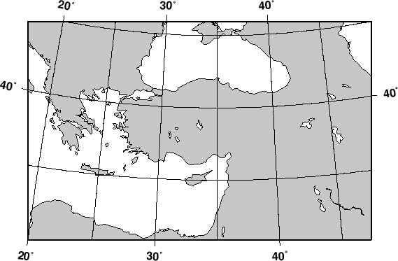
Our example shows a transverse Mercator map of south-east
Europe and the Middle East with 35![]() E as the central
meridian:
E as the central
meridian:
#!/bin/sh
#    $Id: GMT_transverse_merc.sh,v 1.1 2001/03/21 04:10:21 pwessel Exp $
#

pscoast -R20/30/50/45r -Jt35/0.18i -B10g5 -Dl -A250 -G200 -W0.25p -P > GMT_transverse_merc.ps
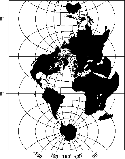
The transverse Mercator can also be used to generate a global map--the
equivalent of the 360![]() Mercator map. Using the command
Mercator map. Using the command
#!/bin/sh
#    $Id: GMT_TM.sh,v 1.1 2001/03/21 04:10:21 pwessel Exp $
#

pscoast -R0/360/-80/80 -JT330/-45/3.5i -B30g15/15g15WSne -Dc -A2000 -G0 -P > GMT_TM.ps
we made the map illustrated in Figure 5.20. Note that
when a world map is given (indicated by -R0/360/s/n), the arguments
are interpreted to mean oblique degrees, i.e., the 360![]() range is
understood to mean the extent of the plot along the central meridian,
while the ``south'' and ``north'' values represent how far from the
central longitude we want the plot to extend. These values correspond
to latitudes in the regular Mercator projection and must therefore be
less than 90 degrees.
range is
understood to mean the extent of the plot along the central meridian,
while the ``south'' and ``north'' values represent how far from the
central longitude we want the plot to extend. These values correspond
to latitudes in the regular Mercator projection and must therefore be
less than 90 degrees.